The State Of Arizona Counties, Cities, Towns, Offices and Public Records
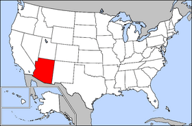
The State of Arizona is located in Western US and features two sub-regions; the Southwestern and Mountain sub-regions. Of the 50 states, it is the 6th biggest and 14th most populated. Phoenix is the state’s capital and biggest city located in the Four Corners area, including Utah, Colorado, and New Mexico. The Navajo Nation is one of 27 federally recognized Native American tribes in Arizona, with the Indian reserves covering one-quarter of the state.
Due to migration from Mexico, the percentage of Hispanics in the state’s population increased dramatically during the 1980s. According to the 2020 Census, the state has a population of over 7.2 million. During the Mexican–American War (1847–1848), the United States claimed land from Mexico south of the Gila River. With the Battle of Picacho Pass in 1862, Arizona boasts the westernmost Civil War military action. The state goes by many names, including Gadsonia, Pimeria, Montezuma, Arizuma, and The Copper State due to its mining industry.
Nonetheless, Arizona became a US state on February 14, 1912. It was the 48th state to join the union and the last of the contiguous states. The government established internment camps for Japanese Americans in Arizona during World War II. After the war, the state’s population exploded due to residential and commercial expansion. Each decade’s percentage increase averaged about 20% in the early decades and over 60% in the following decades. Upon the approval of SB 1070 in 2010, all immigrants were to carry their immigration documents.
Arizona State Counties, Cities, And Towns
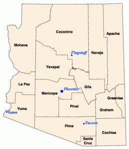
Eight of Arizona’s fifteen counties are named for Native American tribes that exist in now Arizona. Others, for instance, Cochise County after a native chieftain. All of the counties in Arizona except La Paz County existed when Arizona received statehood in 1912. A majority of the votes cast in each proposed new county must accept a motion to partition a county. Besides, counties are state-created political and legal entities that lack their own charters.
Criteria For Forming, Merging, Or Dividing A County
According to the Arizona Laws, a county may not be formed or divided by county initiative in Arizona unless each proposed county meets all of the following criteria:
- At least three-quarters of one percent of the total state assessed valuation, and at least the statewide per capita assessed valuation.
- According to the most recent US decennial census, it must have at least three-quarters of one percent of the total state population.
- At least one hundred square miles of privately owned land.
- Has common boundaries with at least three existing or proposed counties.
To assess the viability of the proposed county, a county formation commission must be established. Similarly, a proposal to divide a county requires a majority of the votes cast in each proposed new county to be approved.
Counties, Cities, And Towns
With a metro area population of approximately 4.7 million people, Phoenix is Arizona’s capital and biggest metropolis. According to the Arizona County Maps, Mesa (Arizona’s third-biggest city), Chandler, Peoria, and Scottsdale are the important cities that make up the Phoenix metro region. Prescott, Cottonwood, Camp Verde, and many more cities make up the Prescott metropolitan area, which spans 8,123 square miles (21,000 km2) in Yavapai County. The world’s greatest collection of Saguaro cactus is visible in Saguaro National Park, located west of Tucson in the Tucson Mountains. This collection of towns is the state’s third-largest metropolitan region, with 212,635 persons.
Yuma is one of the warmest places in the US, with an average July high of 107 degrees Fahrenheit. It is the largest city in the Yuma Metropolitan Statistical Area, with 160,000. Flagstaff, Arizona’s biggest city, is located in Coconino County and is over 7,000 feet above sea level (2,100 m). It is situated at the foot of the San Francisco Peaks, Arizona’s tallest mountain range. The Flagstaff metropolitan area has 134,421 people and is home to Northern Arizona University’s main campus.
Arizona County Offices
The original Capitol Building was constructed in 1901 with a unique copper dome. With Arizona’s entrance to the union in 1912, Phoenix became the official state capital. The Wesley Bolin Memorial Plaza serves as a focal point for the Capitol complex, with the visitors’ lobby situated at the facility. The Governor’s Office is on the ninth floor of this building. Legislators serve for two-year periods and may only serve in one chamber for four consecutive years.
Elected Executive members include;
- Doug Ducey (R), Arizona’s governor.
- The Secretary of State,
- State Treasurer.
- State Attorney General.
- Superintendent of Public Instruction.
- State Mine Inspector.
- Corporation Commission.
All elected officials serve four-year terms for two consecutive terms, except the State Mine inspector’s office, for four terms. The Secretary of State is ineligible if appointed, and the next governor is selected from among the next eligible officials in the line of succession. The governor selects the President of the Senate (Currently, Rusty Bowers) and Court Justices from a list proposed by a nonpartisan panel.
Elected Members To County Offices
The state laws or a charter specific to that county defines a county government’s structure and powers. Elected officers to county offices are in charge of the counties or metropolitan areas. These offices include the following:
- County Commission.
- Board Of Supervisors.
- Commissioners’ Court.
- County Council.
- Board Of Selected Freeholders.
- County Court.
- County Legislature.
A City Council usually governs city/county or city affairs in cases where a consolidated city-county or independent city exists. The elected county executive, chief administrative officer, or county administrator who reports to the board, mayor, or both oversees day-to-day operations in some counties. Nonetheless, several key officials are elected independently of the board of commissioners or supervisors and are not subject to the board’s dismissal. They include the following; County clerk, county treasurer, county surrogate, and county sheriff. District attorneys or state attorneys are usually state-level officials rather than county-level officials, but in many states, the boundaries of counties and state judicial districts are contiguous.
The county seat is the location of a county’s administration, which includes the county courthouse with the county seat in a municipality is usually. On the other hand, some counties may have multiple seats or none; thus, the largest settlement municipality may act as the county seat.
Arizona Public Records
Arizona has had a state records website to make it easier for everyone to find, obtain, and examine public records since 1863. This allows residents of Arizona to access these records under the Arizona Public Records Law, which mandates that all public records be available to the public. According to Title 39 of the Arizona Revised Statutes, all public officers and bodies must keep adequate records to “reasonably” show accurate accounting of their daily operations and official activities or initiatives. That includes Personal, court-related, or business-related records.
Generally, you can find any referenced offices or departments by searching their name plus Arizona. Nonetheless, to locate basic property records, you may contact the County Recorder in the county where the property is. Arizona, like most states, seals adoption records to protect the privacy of children and their families from prying eyes. The Arizona State Library, Archives, Public Records, and the Arizona Judicial Branch aids in the search for state-court records. On the other hand, you may contact the Department of Transportation for vehicle ownership registration records.
For naturalizations records after September 27, 1906, contact the US Citizenship and Immigration Services. However, locating public records for schools is challenging due to the number and types of schools in the state or counties.
List of county seats, cities, towns