Yavapai County
- State
- Arizona
- County Seat:
- Prescott
- Year Organized:
- 1864
- Total Square Miles:
-
8127.94
- Population:
-
228168 (2017)
- Persons/Square Mile:
- 28
County structure
- Government Type:
- County
- Authority:
- Dillon's Rule
- Legislative Body:
- Board of Supervisors
- Size of Legislative Body:
- 5
Demographics
- 2018 Population:
- 228168
- 25 to 64 Years of Age:
- 45.67%
- 65 Years of Age and Older:
- 31.59%
Economy, 2018
- Gross Domestic Product (GDP):
- $6.5 B
- Labor Force:
- 105,618
- Unemployment Rate:
- 4.50%
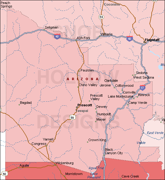
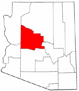
Yavapai County is Arizona’s northernmost county and has over 200,000 people. The first territorial legislature established Yavapai County in 1864, with Prescott as its county seat. Yavapai is a Native American name that means “people of the sun” in English. The seat of government was relocated from Prescott to Prescott Valley in 1891. It was then relocated ten years later to its current location in Prescott.
Visitors and residents alike will enjoy Yavapai County’s many attractions. The town of Jerome is a National Historic Landmark District and one of the most popular tourist destinations in the state. Prescott, the county seat, is located in the heart of Yavapai County.
It has many Victorian-era homes and buildings and a whiskey tasting festival every July.
Clarkdale has an art district with galleries, artists’ studios, and shops, while historic downtown Cottonwood has many wineries and tasting rooms. Watson Lake Park, Granite Creek Park, and Thumb Butte Recreation Area, among others, are great places to go hiking and enjoy nature in Yavapai County.
History of the County
Inspired by the Yavapai people who already lived in the area, the first Anglo-American settlers gave the county its name. The Yavapai and Apache peoples know the “Apache tribes” collectively.
Around 1863, American pioneers established the first settlements in and around Prescott, Arizona.
The early settlements in central AZ were mostly along the waterways. Because of pressure from White American settlers on their lands, the federal government had to create a reservation for them along the Verde River.
To help control the indigenous peoples of this area, the U.S. Army built Fort Whipple (later renamed Fort Myer) near Prescott.
The county was formed after gold was discovered along the Bradshaw Mountains in 1864. Walker (later Congress Junction), Antelope Station (later Congress), and Wickenburg were the first towns established. These settlements made up a small part of what is now Arizona Territory.
These county cities and towns were founded in 1865 by a group led by Charles Poston: Prescott, Wickenburg, and La Paz County (now in La Paz County). After seeing it from afar, Poston planned to name the county “Salt River.”
County Demographics
The U.S. Census Bureau estimated Yavapai County’s population was 209,635 in 2015, representing an increase of 41,671 over the prior decade. According to 2010 Census Bureau information, the county’s population is about 73% urban and 27% rural.
The average population density was approximately 34 people per square mile. Between 2006 and 2008, there was a population increase of 26,000 people.
According to the 2010 census, there were 211,073 residents in Yavapai County. There were 108,365 households and 70,616 families. The population density was recorded at 43.7 residents per square mile.
The county had 158,094 housing units with an average population of 30.8 per sq mile (11.9/km2).
Below is the county’s racial makeup:
- 89.5% were whites
- 0.8% American-Indians
- 0.6% from Asia
- 0.5% African Americans
- 0.1% were Pacific Islander
- 6.3% consisted of other races
County Politics
Since AZ became a state, the Arizona Constitution has shaped the politics of Yavapai County. Yavapai is governed by a Board of Supervisors, consisting of five members elected from the county’s districts. Prescott, the former territorial capital, is the county’s largest city.
Yavapai has a five-member board of supervisors that governs the county. For a four-year term, each supervisor represents their district. The County leadership team is appointed by the Board and serves at the Board’s pleasure. Other officials appointed by the Board include an attorney, engineer, treasurer, and department heads for planning and development, health, library, public works, and human resources.
The current Yavapai County Board of Supervisors are:
- Chip Davis (District 1)
- Rowle Simmons (District 2)
- Craig Brown (District 3)
- Jack R. Smith (District 4)
- Thomas Thurman (District 5)
Voter Registration
As of November 2008, there are 89,835 registered voters in Yavapai County.
- Republican: 50,485 (56%)
- Democratic: 23,974 (27%)
- Other: 15,376 (17%)
Major Attractions in the County
The Yavapai county map is seated in the central part of AZ, including Prescott, Sedona, Jerome, Camp Verde, Chino Valley, and Cottonwood. The county was formed by the Yavapai and Pah-Ute tribes in 1864.
Some of the major attractions of Yavapai County are:
- Prescott: The historic town has grown tremendously through the years with several activities and outdoor recreation opportunities. It’s a great place to spend a long weekend or an entire week.
- Jerome: Once a copper mining town, it is now an artist colony and a ghost town. The old buildings have been preserved, and there are several galleries, museums, and shops to visit. There are also ghost tours available.
- Sedona: Beyond its stunning red rock scenery, Sedona offers art galleries, shopping, hiking, and jeep tours.
County Offices
County Clerks Offices
The clerks’ offices in Yavapai County, Arizona, keep track of the county public records. Following local government regulations and laws, the Clerk’s office provides public access to records.
The Yavapai County Office also aids in the conduct of local elections. Arizona State, Yavapai County, and local government statutes, ordinances, charters, and regulations govern the Clerk’s duties and responsibilities. If you have any questions about what they do contact them through their phone number or (928) 771-3312 orFax: (928) 771-3111.
Listed below are some of their core functions;
- Prepare and distribute election materials; tabulate election results; certify election results.
- Process and maintain all voter registration records for Yavapai County residents.
- Process, maintain, and preserve the official records of the Board of Supervisors.
- Process and maintain vital records (births, deaths, marriages) for the entire county.
- Administer oaths of office to elected officials.
County Recorder
The County Recorder offers several services and resources. Our office issued marriage licenses, concealed weapons permits, birth certificates, death certificates, and record documents that transfer an interest in real property. For all estate cases, the County Recorder also serves as the Clerk of the Superior Court.
These records are kept in our Yavapai County Records Center indefinitely. Its mission is to provide prompt, courteous, and professional customer service while maintaining our records’ accuracy, privacy, and security and providing timely access to information to serve the public with honor, integrity, and accountability.
You may contact the Register of Deeds at (928) 771-3244 if you have any questions about the following issues:
- Property records for Yavapai county map
- Yavapai County, Arizona deed and title searches
- Transfers of property ownership
- Records of military discharge